
The Dingle Peninsula is one of my favourite peninsulas in Ireland. It is in county Kerry and like so many of the most dramatic Irish peninsulas, is on the on the Atlantic coast. The town of Dingle itself is an absolute gem, although Fungi the loveable dolphin is no longer in residence.
The object of this trip was the mountain that stands on the North West edge of the peninsula, a great hulk of a mountain and the highest in Ireland outside of the MacGillycuddy Reeks. I’d been advised to go up from the Faha Grotto side, it being far more rewarding than the long hard slog from Baile Breac, north of Dingle town.
As I started out, a rainbow acted as a welcome arch for the start of the walk; nice and bright but also underlining I could expect all types of weather.

An advantage of going up from the Faha side is that unless the weather is really bad, you are likely to get some sort of view over the sweeping strands of Fermoyle, Cappagh and Castlegregory, to name but a few.
As I made my way up the ridge, I kept turning around to see the increasing panorama, knowing that it would all too soon be hidden in the cloud.

The bright blue sky vanished, replaced by a mournful grey in all directions. Brandon Mountain is known for spending a large part of its existence hidden by cloud, which probably helps to explain the many crash sites of war planes on its slopes. Just above the path is a bench with a plaque to commemorate the crash landing of a Luftwaffe Bomber. Amazingly all six crew survived the crash.

In the photograph above the bench can be seen centre right, just visible in the mist.
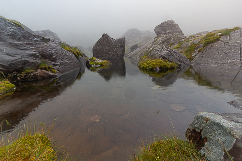
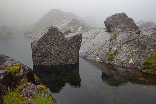
Having got close to the ridge’ top, the path hugs the ridge and gradually gets more rock strewn as the sound of tumbling water grows. The visibility continued to be poor and having passed a few small lochs, it was time to make the steep, rocky ascent to the main ridge.

Hitting the top of the main ridge, it was no longer a matter of being shrouded in cloud, but being submerged in driving wet weather. One has to take one’s luck when it is there, but today I knew there was no hope of any rewarding views from the summit. At the top itself I didn’t bother to take an image, I know I got to the summit.
There was another possible route down to Faha, which can be difficult to identify, as well as being wet underfoot, so I took the sensible decision to descend the way I had come. A helpful sign in the mist made sure no wrong turnings were made.

The sign indicated down, but let’s face it, when you are on top of a ridge almost every direction is down.
Back to the myriad of small loughs I took a break for lunch, becoming beguiled by the eerie atmosphere, clear water and reflections.

Despite having limited vision I could still appreciate why I was recommended to approach the mountain from the Faha side. The walk is broken down into nice neat sections:
- a walk up to the ridge from the Faha Grotto
- hugging the slopes to come into the corrie with many small lochs and escaping cascades
- a steep rocky climb up to the main Brandon ridge that runs in a north-south direction
- a final walk to the summit on a broad ridge
Each change provides something new, as well as breaking the walk down. As I neared the point where I would be leaving the ridge, the view repeatedly came and went with the moving clouds and breaking sunshine. Down here it was a completely different day.


Behind me dense cloud remained.

So without further ado, may I suggest we drop down further, revel in the view eastwards towards Tralee and reward ourselves when we reach the sea.


On the final part of the hike I met a man who had been living in the area for a good number of years and regularly climbed Brandon. It seems the mountain hides its treasures well, the hiker has yet to have a clear view from the summit. Then there was the lady at the bed & Breakfast, claimed to have climbed the mountain three times in total and in going up with the local hiking club got a perfect vista on a December walk. You just have to take your chances when you can.

What a wonderful climb! The pictures are lovely, John (even with the clouds 🙂 )
LikeLiked by 1 person
Clouds can often make a picture, but in reality not these. It was though hypnotic to see the scenery come and go as I stood still. I prefer stills, but in this instant a video (or time lapse) may have been more appropriate. hugs to you my friend xx
LikeLiked by 1 person
I get it! And it would have been lovely to watch, I’ve no doubt.
Hugs right back, my friend! xo
LikeLiked by 1 person
Fabulous scenery!
LikeLiked by 1 person
For me the best peninsula in Ireland, it really is. Ryan’s daughter was filmed there at Slea Head.
LikeLiked by 1 person
Ah, right
LikeLike
Bueatiful place and very interesting. The reward was well worth the trip, ha!
LikeLiked by 1 person
Oh the reward went down well, watching people jump off the pier. Dingle is a fantastic peninsula and I have just come back from another trip to the area, just a little bit further west (not that there is much to go before dropping off into the Atlantic.
LikeLike